Northern Spain is a walker and hikers paradise
Bilbao & Beyond
Spain
Bilbao to Portugalete
The Basque region is a walker and hikers paradise. Several short bus or train rides away from our home town of Bilbao landed us in some extraordinary places for our 7 Northern Spain Walks
43.2630° N, 2.9350° W to 43.3182° N, 3.0212° W
The Vizcaya Hanging Bridge
On a sunny January morning we took a short rail trip from the center of Bilbao to the thriving riverside towns of Portugalete and Getxo. Both cities are situated along the Nervión River and are connected by the Vizcaya Bridge, listed as a UNESCO World Heritage site. Essentially the Vizcaya Bridge is an oversized gondola that can transport six cars and several dozen passengers across the river in one and a half minutes without obstructing the path of passing ships. It was something that had never been built before and has few rivals to this day. Yet another miracle from the Industrial Age.
Although these sister towns are separated by the Nervión River they share a common history rooted in maritime professions and the heavy industrialization that the northern region of Spain went through starting in the late 1800’s. The Vizcaya Bridge serves as both the physical and social connection between the two cities.
Our three hour walk began once we exited the Vizcaya Bridge on the Getxo side of the river. Stretching from the bridge we walked along the “Paseo de las Grandes Villas” which showcases many of the opulent, palatial homes built during the great economic boom of the 1800’s.
Once past the stately mansions we climbed the steep staircases that lead to the Old Port of Algorta, a small traditional fishing village with winding cobblestone streets and whitewashed houses trimmed in traditional Basque country colors. This picturesque area is a popular meeting place to enjoy pintxos, seafood or drinks while overlooking the sea. Descending from the the tangle of houses dominated mainly by local felines, the path turned right and climbed high above Arrigunaga beach, a favorite among locals and tourists alike. It is on this path that we were able to take in sweeping views of the Bay of Biscay and the vertiginous, horseshoe shaped cliffs that frame the beaches below. The geology of this region is well written on the charcoal gray cliffs, beaten by eons of wind and pounding surf. Many observers have commented that the cliffs resemble the famous white chalk cliffs of Normany in France or the Dover cliffs in England.
On our return trip we stopped at the famous Aixerrota Windmill for some lunch and an opportunity to take in another bit of Getxo’s history. Of all the windmills erected in Getxo during a massive drought this is the only one that remains standing. If your only vision of windmills is Holland…think again. Put into operation in 1726-1727 it stands alone as a testimony to the ingenuity of the Basque people.
While this was certainly not one of our more strenuous outings it ranks among the most pleasant. Observing multi-generational families, couples pushing strollers and locals enjoying lunch at the numerous sidewalk cafes was truly a snapshot of what makes living in this part of the Basque region so special.
And of course there were dogs…many, many dogs!


Bilbao to Orozko
43.2630° N, 2.9350° W to 43.1076° N, 2.9113° W
Gorbeia Natural Park
On another pre-dawn morning we boarded a bus that would take us south to the 14th century town of Orozko where we began our 15 mile walk through numerous small villages in the direction of the renowned Gorbeia Natural Park. With a total population of under 3000 Orozko feels much further away, in distance and in time, than the 20 mile hourlong ride it took to arrive in the central plaza from Bilbao.
Leaving the central plaza in Orozko we headed down a two lane road under mercury colored skies that threatened rain at any moment. Not knowing where we were going we followed the signs to Gorbeia Natural Park knowing that it would be impossible to lose our way. Soon the road narrowed and we found ourselves passing through incredibly charming villages with no more that 15-20 houses as locals greeted us with warm smiles and waves.
As we continued our journey alongside a crystal clear river we noticed two men hovering over an animal on opposite tables just outside their workshop. Our curiosity and desire to get closer was dampened by the presence of several barking dogs. Nonetheless we took a chance and greeted them with a hearty “hola!” Sensing that we wanted to have a closer look at what they were doing they waved us on to come and visit.
Sure enough they were butchering a wild boar that they had killed earlier that morning. As it turns out they were two brothers among seven who had grown up in the centuries old farmhouse. One brother specialized in skinning the kills while the other was in charge of the butchering while, as might be expected, the dogs specialized in vacuuming up whatever scraps the brothers threw to them. It was a fascinating hourlong encounter made more so by their unfailing friendliness and hospitality. It was an encounter we would have regretted had we not taken a chance.
We continued until a sign for Gorbeia Natural Park pointed us in the right direction. Walking along a sweeping valley hemmed in by mountains on both sides we were treated to the most bucolic landscape of centuries old farmhouses, grazing sheep and yet another rushing river. There was not a trace of anyone save an elderly gentleman doing his best to piece together a broken down fence. After several miles we realized that the entrance to the park was still a considerable distance off and there would not be enough time to fully explore it. With dark skies looming we briefly rested in a small park and resigned ourselves to returning to Orozko.
Luckily for us the rain never came. That was, until we were on the return bus to Bilbao.


Bilbao to Gaztelugatxe
43.2630° N, 2.9350° W to 43.4470° N, 2.7850° W
San Juan de Gaztelugatxe
Rubbing the way-too-early morning sleep from our eyes we left our apartment to board the bus from Bilbao to the town of Bakio, which was our first stop on the way to the famous Shrine of San Juan de Gaztelugatxe. Leaving the dimly lit streets of Bilbao the bus sliced its way through the mountains north of the city. It wasn’t long before we were treated to a sunrise bursting with color as shades of pink, rose and crimson coaxed us to open our eyes and heed natures wake up call.
An hour and a half later, with eyes wide open, we were dropped off in the seaside town of Bakio. Due to the narrow roads leading from Bakio to our final destination the second leg of our journey would be in a minivan driven by a man who would have preferred to stay in bed rather than picking up two turistas so early in the morning. We boarded the van as our grumpy driver mumbled something under his breath and off we went to our final drop off point…the Eneperi restaurant. Dating back to 1816 the Eneperi restaurant began as a traditional Basque country house where several generations made their living on farming and livestock. The original house has since been renovated and converted to a restaurant and museum (both opened in 1994). These days the restaurant not only feeds hungry daytrippers but also serves as the official gateway to the Shrine of San Juan de Gaztelugatxe.
Anxious to start our trek to the shrine we hastily departed the van and began the long descent toward the bridge that connects the mainland to the islet. San Juan de Gaztelugatxe is connected to the mainland by a stone bridge and a stretch of land forming two arches. The opposite end of the bridge abruptly turns into a steep, zigzagging and heart pounding 241-step staircase leading to the top of the rock, where the picturesque shrine stands.
Breathless, we finally reached the summit and took in the magnificent views up an down the coast, stretching from Bakio to Cape Matxitxako. The dramatic landscapes were some of the most spectacular we witnessed on entire Cantabrian coast. Being that it was late January there was a distinct chill in the air, accompanied by platinum and pink skies. Perhaps it was the time of year, or the moody weather, but once again we found ourselves, as we had on so many of our walks and hikes, nearly alone in this mystical place.
After more than an hour our peaceful sojourn atop the islet was over and with hunger getting the better of us we started the long journey back. Descending the stairs was considerably easier on the lungs, if not our knees, yet the views were as incredible as they were on the way up. Pausing frequently to take in the amazing vistas was made all the more pleasant due to very little cross traffic heading up to the shrine.
Back at the Eneperi restaurant we stopped in for a well earned round of pintxos and a couple of cold beers before being picked up by none other than the same driver that escorted us in the morning. Wide awake by now he was in considerably better spirits…especially when he found out that we were from California, a place that he had once visited!


Logrono to Navarette to Ventosa
42.4627° N, 2.4450° W to 42.4038° N, 2.6258° W
El Camino de Santiago de Compostela
This was absolutely one of our favorite all day walks, not just in Spain but among the many throughout our travels.
Our day began a bit tricky at first as we departed Logrono very early (again!) and the morning light had yet to show itself. We knew how to get to the first leg of the Camino as it was well signed and conveniently located along the beautiful Ebro river at the Puente de Piedra bridge. The Puente de Piedra bridge is one of four bridges spanning the river as well as one of the more prominent symbols of Logrono.
Once on the trail finding our way became a bit more challenging as there were few signs helping us to stay on course as we exited the city. Fortunately with the help of several friendly locals we managed to navigate until we began to see the familiar scallop shell and yellow arrow symbols which are the official markings of the Camino de Santiago. The scallop shell is believed to be a metaphor with its lines representing the different routes that pilgrims travel from around the world to arrive at one singular point…Santiago de Compostela.
On the first leg of our journey we walked from Logrono to the village of Navarette, a community of 3000 people with a national designation as a Conjunto Histórico-Artístico of Spain, due to its historical and architectural character.
The walk to Navarette was close to eight miles yet it took us over three hours due to stopping to explore La Grajera park. More than a century ago the park was nothing more than a large reservoir built to irrigate the city’s orchards. Today it is as popular with Logroñeses as Central Park is to New Yorkers. It is also a great resting place for people from around the world traveling this section of the camino.
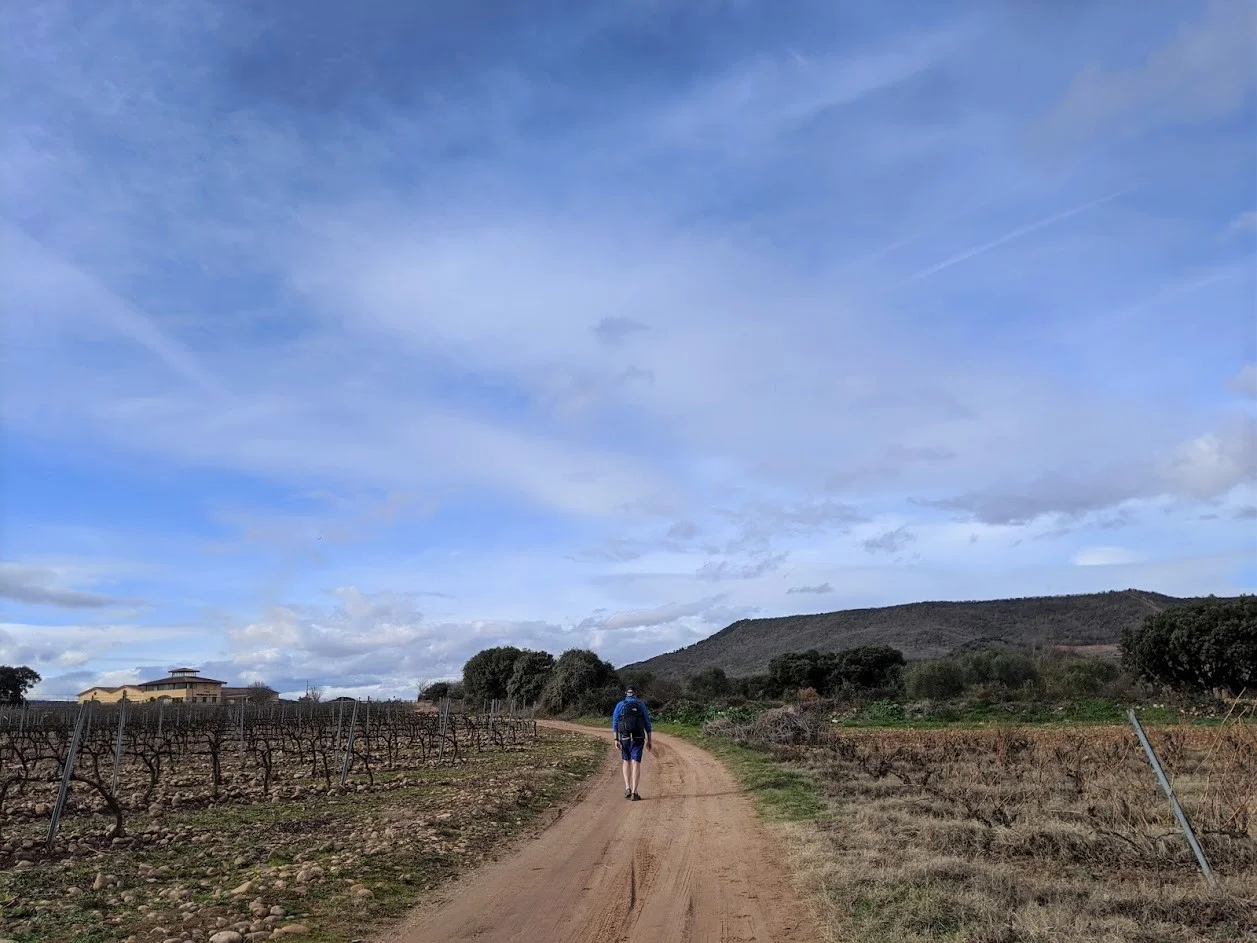
Leaving La Grajera park we walked for miles on a wide dirt trail through vineyards sleeping in the winter sun. Row upon row of ancient vines, some bearing clusters of unpicked shriveled grapes, were rooted in the stone and gravel that gives this region its distinctive terroir. Knowing that there are many different routes of the camino, from urban legs to vast distances in the countryside, this was the first stretch of our walk that began to feel like the camino we had envisioned.
Once in Navarette we sat on a bench in the central plaza and enjoyed our well deserved lunch before heading to Ventosa. The pilgrimage route passes through this medieval village and runs right along the main street allowing us to take in the centuries old houses, palaces and churches.
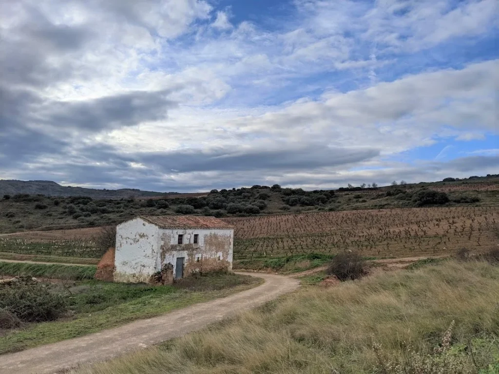
The distance from Navarette to Ventosa was just shy of five miles but is was a glorious walk punctuated by sweeping vistas, acres of vineyards and the constant companion of the warm, early winter midday sun. This is the type of light and landscape that has inspired countless plein-air painters.
Arriving in Ventosa tired and hungry we settled into Bar Deportivo, a small restaurant that appeared to be the only place open. As the owner served us some well earned pinchos and cold beer, we inquired as to where everyone was. When she informed us that Ventosa is a village of less than 300 people and that January is not the highest season for camino travelers it was easy to understand why it felt so quiet. Once again we found ourselves alone in what would normally be a throng of turistas and camino enthusiasts.
Taking advantage of what little remaining warmth the day had to offer we departed Ventosa for the return trip to Logrono. As the late afternoon shadows lengthened we caught our last glimpse of the sleeping vineyards as they seamlessly blended with the distant mountains in a rust colored tapestry.

Vigo to “La Ruta de Agua”
42.2406° N, 8.7207° W
The Senda del Agua (Water Trail)
The Senda del Agua (Water Trail) is a beautiful nature trail a short 30 minute ride from the bustling port city of Vigo. The original channel carried water from the Eiras reservoir to Vigo. Today it is a popular walking trail with great views, fresh air and a feeling of being further from the city then it actually is.
We boarded the bus in Vigo for the short trip to the working class neighborhood of Lavadores. On the ride to Lavadores we crossed over the Rande Bridge, widely considered to be among the most distinctive bridges in Spain. Crossing the bridge provided us with amazing views of the enormous Vigo Estuary along with the Cies Islands in the distance. As the Vigo estuary’s greatest treasure it’s no wonder that the Romans named them the “islands of the gods”.
Once in Lavadores we needed help from several locals for the right direction (generally up!) to the Senda del Agua. Properly oriented we began the long ascent toward the forested trails and numerous waterfalls. Soon the roads that ran through several residential enclaves turned into something more like a real trail and we found ourselves surround by forests, streams, waterfalls and numerous fresh water fountains. We walked for the better part of two hours enjoying the warm climate and empty trails that, on any given weekend, would be trafficked by hundreds of day trippers from Vigo and the surrounding neighborhoods.
Throughout our walk we passed numerous reminders from when the reservoir supplied the growing city with fresh water. There were abandoned pumping stations, rusting pipes and valves along with the broken down remnants of what appeared to be houses. It its time the project was an engineering feat with great commercial purpose as it not only provided precious drinking water but also immeasurable amounts of ice that help support Vigo’s fishing industry which to this day, remains one of the largest in Europe. However, like so many projects of its kind it was eventually abandoned and left to the ravages of time, progress and nature.
Toward the end of our walk we spotted a brightly colored painting of a tropical fish on a large boulder. Sharing space on the boulder was the familiar scallop shell plaque denoting yet another route of the Camino de Santiago. Seeing the plaque we knew that we were, once again, headed in the right direction back to the City of Olives.


Vigo to Islas Cies
42.2406° N, 8.7207° W to 42 ° 13 '59.448 "N, 8 ° 43' 54.408" W.
Cies Islands
The first time that we saw a promotional billboard for the Islas Cíes declaring them the most beautiful islands in Europe as well as possessing some of the finest beaches in Spain we blithely ignored it as turista marketing 101. However, the idea of visiting a pristine chain of islands a mere 40 minute ferry ride from Vigo continued to resonate as something that we should be open-minded about. After visiting the ferry office and learning more about this magical place we knew that we had to go.
With tickets in hand we boarded the 10:00 am ferry under deep blue skies, calm waters and little to no breeze. Soon we disembarked onto a strikingly beautiful horseshoe shaped white sand beach that looked like a set from a Caribbean movie. As advertised, it was in fact pristine made all the more so due to the fact that there were no cars, no hotels, no trash and no sign of humans, except our fellow day trippers. And to think that it was a little over half an hour from one of the busiest fishing ports in the world. Paradise was a word that we would repeat over and over during our 4 hour adventure.
Knowing that we had roughly 5 hours to explore the islands we decide to stick to Illa do Faro with its mix of seaside bluff vistas and inland trails, two of which led to lighthouses…one older and one considerably more modern. Our first trek was to the Faro da Porto, and easy trail to the older of the two lighthouses with astounding views to Illa de San Martiño. A brief rest and we were off to the second, and more challenging of the two lighthouses.
The trek to the Faro de Cies lighthouse is one of the most iconic trails on all of the islands as well as the longest at around nine miles from base to summit. Although it is a grueling climb the switchback trail made it a little less taxing on our lungs…and our legs! Once at the summit, which is the highest point on the island, all concerns about sore calf muscles quickly subsided as the views up and down the archipelago replaced the pain with the rush of absolute wonder. Keen to relax we took in the cool ocean breeze rushing up the cliffs while watching sea birds dart in and out of their secret hiding places in the crags below.
Mindful of the fact that the ferry departed at exactly the scheduled time we headed down from Faro de Cies with calves rejoicing in the descent. Soon we were back on level ground enjoying the forests and the serenity that being completely alone offers.
Check out our Spain’s Cies Islands article with more pictures!


Santiago de Compostela
42.8782° N, 8.5448° W
Finisterre (The End of the Earth)
On the last day of our five day stay in Santiago de Compostela we decided to take a late afternoon walk on the only leg of the Camino trail that starts in Santiago de Compostela which finishes in Finisterre on the stunning Atlantic coast of Galicia. In old times Finisterre was believed to be “the end of the earth” and the place where the sun died and the worlds of the living and the deceased drew closer.
The route to Finisterre is a distance of roughly 54 miles and normally requires four to five days to complete. Our afternoon walk would fall far short of that at only four hours yet is was a leisurely outing as we walked through the beautiful countryside high above Santiago, passing small enclaves of homes with their ancient communal granaries struggling to stay aloft on crumbling, vine encrusted legs.
It was a quiet and very serene walk as we barely encountered any pilgrims or day trippers. Looking back over our shoulder we could see the enormous Cathedral of Santiago de Compostela, which serves as the final resting place for thousands of pilgrims entering the city on foot or bike.
No matter the time of year, the weather or the distance traveled, the Camino and its various routes, is a living testimony to faith, endurance and perseverance for people the world over. We were more than happy to experience yet another portion of this historic trail.


